

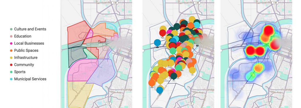
.png)


City managers derive significant benefit from understanding their citizens’ needs, and there has been a fantastic rise in technologies that help them do just this. One element that can make information on citizen needs even more valuable is knowing where those needs are. That’s where geolocation technology comes into play. At Zencity we developed Name Entity Recognition, which is a tool that enables cities to extract locations from data like social media posts, tweets, and other written content based on what a citizen is talking about. Through this extraction, cities can have a more complete grasp of citizen feedback, especially when it’s regarding a specific landmark, city facility, neighborhood, or district. The maps below reflect geolocation technology at work in three different ways, displaying leading topics in each neighborhood in a Leading Topic Map; topics across the entire city in a Topic Map; and the level of discourse about each area of the city in a Heat Map.
Why Is Geolocation Data Valuable for Cities?
Geolocation technology enables a city to understand pitfalls, issues, and resident needs and priorities according to location. This kind of information helps city managers divvy up responsibilities and resources amongst various municipal departments and projects by neighborhood, district, or any other delineation. A city manager can apply geolocation data to target efforts towards a very specific problem area as opposed to applying a general solution to a larger area, for example, during a snowstorm, assigning snow plows based on location details in tweets rather than citywide. Similarly, cities can develop different solutions to similar challenges across different sections of the city.
Understanding citizen needs according to the “where” being communicated gives cities invaluable, nuanced insight into citizen feedback. Meeting citizens needs – especially very localized ones – in a way that genuinely reflects citizen sentiment also increases public trust. Integrating this information into communication with citizens can also provide exponential value to a city’s citizen engagement efforts. Cities who are able to focus engagement on the issues relevant to a specific neighborhood can interact with their citizens more meaningfully and can engage in a more localized way.
How Does Advanced Geolocation Technology Enhance Smart City Solutions?
Geolocation data reflects what topics are being discussed in the city by area, and where in the city the most amount of discourse about the city is taking place. Geolocation technology takes this data and imposes it on a city map that is integrated with the city’s GIS layer, representing the way the city thinks about its own geography. At the basic level, a city map with geolocation data reflects items that have a specific location provided like a social media “check-in.” But at Zencity we decided to enrich this data by also obtaining location from text content – the name of a park, a school or an intersection, for example.
The technology which enables Zencity to extract location by text provides a significantly higher quantity of data enabling the development of a combination of maps that can show, in real-time and according to neighborhood, what the leading topics being discussed in each neighborhood are (a leading topic map), the different discussion points across the entire city (a topic map), and the amount of discourse happening in different areas of the city (a heat map).
These geolocation tools are not about where the citizen providing feedback is physically located, rather it’s about what the citizen is saying about a specific location in an area of the city.
Why Is Extracting Geolocation Data a Real Technology Challenge?
So what’s so advanced about extracting locations from social media posts and other written content anyway? This kind of location extraction is advanced because of how difficult it is to interpret location from the way people write on social media using the vernacular, shorthand, and without anywhere near-complete location details. Even the name of the city itself is often missing, let alone an address of course.
Name Entity Recognition (NER) technology is an NLP (Natural Language Processing) classifier algorithm that can, from textual data, extract defined entities such as a person, an organization or a location without all of the information you would usually think would be necessary to identify the where in citizen feedback. NER enables the Zencity Insights tool to process any textual data and extract a location based on the mention of specific types of words.
The algorithm used is important but building a good dataset was just as important. From the technical side, this meant teaching the algorithm how to understand the types of data that are being analyzed by the Zencity tool, and training the algorithm to understand entities linked specifically to cities. Having an appropriate dataset, an adapted text cleaning, and a well-chosen Machine Learning algorithm made it possible in the development of NER, and together the three have produced a next-level geolocation tool.
What Are Cities Doing with Geolocation Technology?
Although we just recently launched our new geolocation technology, we’ve already seen geolocation data play a crucial role in decision making and citizen engagement. In one city, our data helped protect the Little League in a neighborhood where the park safety measures where the team practiced weren’t up to par. In another city, a Mayor has been using our geolocation technology to prepare for neighborhood town hall meetings, arriving at each neighborhood meeting prepared, and engaging in more meaningful discourse with the citizens. In another city, the data has been essential in providing different services to different city districts and in allocating responsibility to different departments across the different districts.
Our main goal at Zencity is to help city managers understand their citizens and answer their needs in the best way possible. We believe that our NER geolocation technology is a tremendous step in that direction.
Ready to get started?
Reach out to our team to schedule a demo.
